
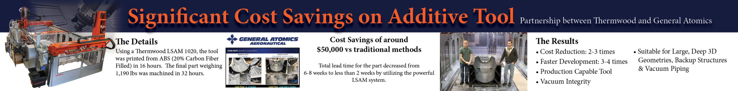

Elysium has developed an advanced functionality to automatically extract piping and planar surfaces for building-information modeling (BIM) from scanners used by UAVs (Unmanned Aerial Vehicles, aka drones) and MMS (Mobile Mapping Systems)—in addition to currently supported feature extraction from tripod scanners. The new capability will be embedded in the latest version of Elysium’s point-cloud utilization software, InfiPoints, released today.
Realizing Automated CAD Modeling Workflows with Scans from UAVs / MMS
3D scanning has spread worldwide in the architecture, engineering, and construction (AEC) industries. Along with the tripod 3D laser scanner, large-scale sites such as chemical plants, bridges, and roads are using mobile scanning methods to capture the real environment for modeling, analysis, and archiving.
Wide-scale areas can be covered with a hybrid combination of various scanners. This is valuable but using mobile devices during the scanning process can limit information, such as the relationships between point-cloud data origin and the in-between points needed for complete data capture. This can result in time-consuming efforts for proper configuration of data, including registration and modeling of data from individual mobile scanners. Similar issues can be seen when capturing data from UAVs or photos.
Elysium has developed technology to complement any missing information in point-cloud data with InfiPoints’ advanced processing capabilities—such as feature extraction of pipes and planar surfaces and automatic registration. This functionality allows users to accurately combine and perform registration between UAV/MMS-scanned point clouds and point-cloud data captured from tripod 3D laser scanners. The results are that the scope of efficient modeling using InfiPoints has broadened significantly from past standards.
Applications for Handheld Scanner Point Cloud Data
The new technology can be applied not only with UAVs and MMS, but also with handheld scanners that are often used for smaller-scale retrofitting and engineering. Backpack scanners and cart scanners used for narrow-area scanning can also be supported by this new functionality. Users of other point-cloud processing software may find that there are cases in which their exported point-cloud data does not retain the structured information contained in the scans. InfiPoints’ new functionality allows users to complement and then augment lost information so they can fully utilize InfiPoints’ automatic processing technologies for improved feature extraction and registration.
Using this new Elysium functionality, users can add scan data from complementary scanning devices—such as a handheld scanner that has scanned a piece of equipment for replacement—and register that data as a complement to data already acquired from, say, an existing tripod scanner.
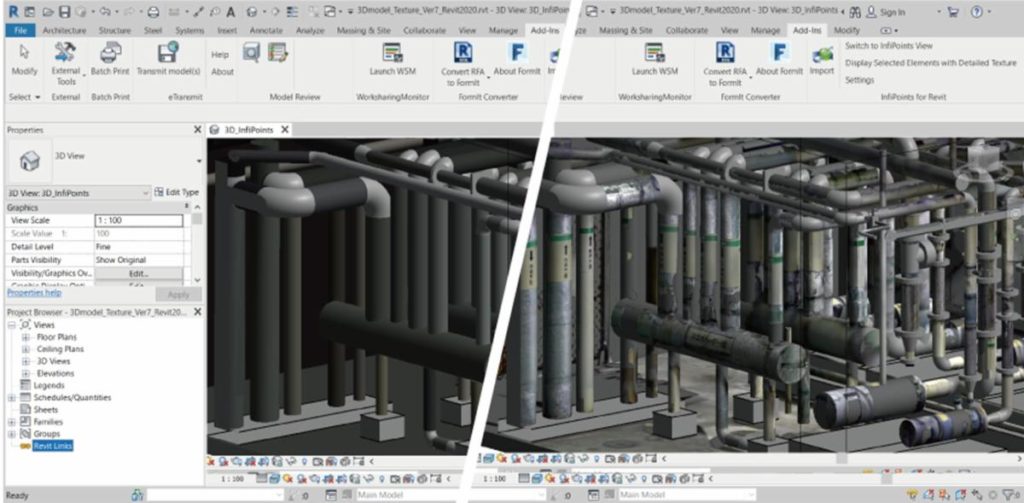
Automatic Texture Generation for More Efficient CAD Modeling Workflows
InfiPoints has the capability to generate CAD models from scanned point-cloud data and deliver that data to BIM software. The software originally exported CAD data as unicolor solid models. Elysium has now developed a new capability to generate a CAD model that includes texture from the point-cloud data color information. This will be a notable leap above exporting a monochromatic model, as it enables users to have a more realistic experience when working in BIM software’s detailed design and modeling. Also, of significance, the modified data size is lighter compared to the original point cloud and suitable for use with presentations and discussions between partners and customers.
“Using 3D laser scanning has become more and more common with the advancement of the technology and, while it was once a technology for early adopters, it is now expanding towards the early majority market,” says Atsuto Soma, CTO of Elysium. “The modes and tools to capture point clouds have grown and diversified, along with the needs of the users across many engineering applications. Elysium’s newest InfiPoints enhancement for the BIM market demonstrates influential capabilities of automatic registration and feature extraction that deliver seamless use regardless of the hardware or point cloud capturing method.
“Some industries and users have hesitated in the past when faced with the heavy file size that point clouds generate,” Soma notes. “In contrast to photos that lack clear visibility, the new capability of InfiPoints to add textures should help bring down that barrier and further accelerate more widespread use of 3D laser scanning technology that takes advantage of the productivity benefits provided by InfiPoints.”
Remember, you can post AM job opportunities for free on 3D ADEPT Media or look for a job via our job board. Make sure to follow us on our social networks and subscribe to our weekly newsletter: Facebook, Twitter, LinkedIn & Instagram! If you want to be featured in the next issue of our digital magazine or if you hear a story that needs to be heard, make sure to send it to contact@3dadept.com


